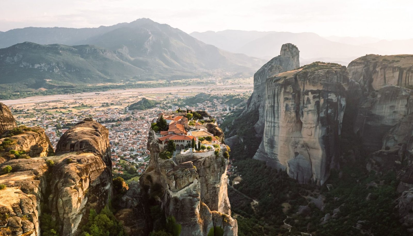
Imagine hovering high above the ancient stones of Machu Picchu, capturing the symmetrical beauty of the Taj Mahal from a perspective few have witnessed, or revealing the true scale of the Colosseum as your drone glides gracefully overhead. Drone photography has revolutionized travel blogging, transforming how we document and share the world’s most iconic landmarks.
In this comprehensive guide, I’ll cover everything you need to know about photographing famous landmarks from above—from selecting the right equipment and mastering technical skills to navigating legal requirements and creating compelling visual narratives. Whether you’re a seasoned travel blogger looking to add a new dimension to your content or a drone enthusiast eager to showcase architectural wonders from fresh angles, this guide will help elevate your aerial photography to new heights.
Get ready to capture breathtaking perspectives that will make your audience feel like they’re soaring alongside you. Let’s embark on this aerial adventure together!
Table of Contents
- Understanding Drone Photography Basics
- Selecting the Perfect Drone for Landmark Photography
- Essential Gear and Accessories
- Packing and Traveling Internationally with Your Drone
- Legal Requirements and Regulations
- Planning Your Landmark Drone Shoots
- Mastering Aerial Photography Techniques
- Optimal Camera Settings for Landmark Photography
- Creative Perspectives for Capturing Landmarks
- Weather Considerations for Drone Photography
- Post-Processing and Editing Drone Footage
- Safety Precautions While Flying Near Landmarks
- Integrating Drone Content into Your Travel Blog
- Building an Audience with Your Aerial Content
- Conclusion
Understanding Drone Photography Basics
Before we dive into the specifics of landmark photography, let’s establish some foundational knowledge about drone photography.
Drone photography combines traditional principles, unique challenges and opportunities, and aerial perspectives. Unlike ground-based photography, drone work requires understanding three-dimensional space, flight dynamics, and remote camera operation.
The key advantages of drone photography for landmarks include:
- Revealing context: Aerial shots show how landmarks fit into their surroundings
- Capturing scale: Drones help convey the true magnitude of architectural marvels
- Discovering details: Birds-eye views can reveal patterns and features invisible from the ground
- Creating unique content: Aerial perspectives still offer novelty in a saturated content market
However, drone photography also presents unique challenges: limited flight time, weather dependencies, and complex regulations—especially around famous landmarks, which often have restricted airspace. Understanding these fundamentals will prepare you for the techniques needed to capture landmarks effectively.
Selecting the Perfect Drone for Landmark Photography
When photographing iconic landmarks, your drone choice can significantly impact your results. Here’s a comprehensive comparison of the top options for travel bloggers:
| Drone Model | Key Features | Camera Specs | Flight Time | Weight | Best For |
| DJI Mavic 3 Pro | Hasselblad camera, omnidirectional obstacle sensing | 4/3 CMOS sensor, 5.1K video | 43 minutes | 895g | Professional landmark photography, cinematic footage |
| DJI Air 3 | Dual camera system, 10-bit D-Log M | 1/1.3-inch CMOS sensor, 4K/60fps | 46 minutes | 720g | Mid-range travel bloggers seeking quality & portability |
| Autel EVO Lite+ | 6K video, 20MP stills, 40-minute flight time | 1-inch CMOS sensor | 40 minutes | 835g | Versatile landmark photography, longer distances |
| DJI Mini 4 Pro | Ultralight, omnidirectional obstacle avoidance | 1/1.3-inch CMOS sensor, 4K/60fps | 34 minutes | 249g | International travelers, beginners, and people from restricted countries |
| Skydio 2+ | AI obstacle avoidance, autonomous tracking | 1/2.3-inch CMOS sensor, 4K/60fps | 27 minutes | 800g | Capturing landmarks in challenging environments |
When selecting your drone, consider these factors specifically for landmark photography:
- Camera quality: Higher resolution and larger sensors capture architectural details better
- Portability: International travel demands compact equipment
- Flight time: Longer battery life gives you more opportunities to find the perfect angle
- Stability: Wind resistance is crucial around tall structures
- Smart features: Automated flight modes can help create dramatic reveal shots of landmarks
For most travel bloggers focusing on landmarks, the DJI Air 3 offers an ideal image quality, portability, and price balance. However, if the budget allows, the Mavic 3 Pro’s superior camera system captures architectural details with remarkable clarity. If traveling to countries with strict drone weight regulations, the Mini 4 Pro is the choice despite its slightly smaller sensor.
Essential Gear and Accessories
Beyond the drone itself, several accessories can dramatically improve your landmark photography experience:
- ND Filters: Essential for controlling exposure when shooting reflective surfaces like the glass of modern landmarks or water features
- Extra Batteries: Always carry at least three batteries to maximize shooting opportunities at each location
- Memory Cards: High-speed, high-capacity cards (64GB+ UHS-I/V30 minimum) prevent buffering during 4K/5.1K recording
- Portable Charging Hub: Allows recharging batteries between locations
- Hard Case: Protects your investment during international travel
- Landing Pad: Provides clean takeoff surface in dusty archaeological sites
- Tablet Mount: A Larger screen helps frame architectural details more precisely
- Range Extenders: Useful for maintaining connection when shooting large landmarks
Investing in quality accessories protects your equipment and expands creative possibilities when photographing landmarks from above.
Packing and Traveling Internationally with Your Drone
International travel with drone equipment requires careful planning, especially when visiting multiple countries with famous landmarks. Here’s how to ensure your gear arrives safely:
Packing Strategy
- Use a dedicated hard case with customizable foam inserts like the Pelican 1535 Air or HPRC cases.
- Remove propellers and store them separately to prevent damage
- Secure batteries in LiPo-safe bags with terminals covered
- Pack the controller with joysticks removed, if possible
- Include essentials like spare parts, tools, and cleaning supplies
Air Travel Considerations
- Carry your drone onboard as hand luggage—never check it
- Research battery regulations for each airline (most limit to 100Wh batteries)
- Bring battery documentation showing specifications
- Prepare for security questions by understanding your equipment
- Label everything with contact information
Arrival Preparation
- Register your drone in advance for countries requiring it
- Download local flight maps before arriving
- Carry printed copies of permits and registrations
- Have insurance documentation readily available
This methodical approach to packing and preparation ensures that once you arrive at your destination landmarks, you can focus on photography rather than logistical challenges.
Legal Requirements and Regulations
Navigating drone regulations around iconic landmarks presents one of the biggest challenges for aerial photographers. Here’s what you need to know:
General Regulatory Considerations
- Most countries require drone registration for units weighing over 250g
- Many landmarks have designated no-fly zones extending several kilometers
- Special permits may be available for commercial photography at certain landmarks
- Local authorities often have different rules than national regulations
Notable Landmark Restrictions
- Eiffel Tower (France): Prohibited within Paris city limits
- Taj Mahal (India): No-fly zone extending 5km
- Colosseum (Italy): Requires special municipal authorization
- Pyramids of Giza (Egypt): Special permits are required, rarely granted
- Machu Picchu (Peru): Strictly prohibited without archeological authorization
Obtaining Permissions
- Research regulations months in advance
- Contact local aviation authorities
- Apply for special permits where available
- Consider hiring local fixers who understand permit processes
- Document all approvals and carry them while shooting
Insurance Requirements
- Many countries require liability insurance for drone operations
- Consider specialized drone insurance covering damage and third-party liability
- Some landmarks require proof of insurance before granting permits
The legal landscape continues to evolve, so always check the most current regulations before traveling. When in doubt, consult with local drone communities or professional photography guides who specialize in your destination.
Planning Your Landmark Drone Shoots
Successful landmark drone photography requires meticulous planning:
Research Phase
- Study existing aerial photos of your target landmarks
- Use Google Earth to pre-visualize angles and approaches
- Research sun position for optimal lighting on structures
- Identify potential takeoff and landing locations
- Find reference points for scale and orientation
Creating a Shot List
Develop a detailed shot list for each landmark including:
- Wide establishing shots showing context
- Medium shots highlighting notable features
- Close-up detail shots of architectural elements
- Dynamic movement sequences
- Transitions between key features
Timing Considerations
- The golden hour provides warm, dramatic lighting for most landmarks
- Blue hour creates stunning contrasts with illuminated structures
- Early morning often means fewer tourists and clearer air
- Seasonal factors like flowering gardens or snow can add interest
Location Scouting
- Arrive at least a day before to scout locations physically
- Identify obstacles not visible in satellite imagery
- Confirm take off areas are accessible and legal
- Evaluate signal interference from nearby structures
- Assess crowd patterns to find quieter periods
Creating a detailed flight plan for each landmark maximizes your limited battery time and ensures you capture all necessary angles for compelling content.
Mastering Aerial Photography Techniques
Photographing landmarks from above requires specialized techniques:
Composition Strategies
- Use the rule of thirds to balance architectural elements
- Create leading lines that draw attention to the landmark
- Incorporate natural framing from surrounding landscapes
- Find symmetry and patterns in architectural designs
- Include human elements for scale when appropriate
Movement Techniques
- Orbit shots circle landmarks to reveal their three-dimensional form
- Reveal shots start tight and pull back to showcase scale
- Parallax moves glide past foreground elements to create depth
- Top-down progression starts high and gradually descends
Advanced Manoeuvres
- Point-of-interest mode for smooth circles around central structures
- Waypoint missions for repeatable, precise movements
- Focus tracking to maintain sharp detail on moving elements
- Panorama stitching for ultra-high-resolution landmark captures
Practice these techniques in less restricted areas before attempting them at famous landmarks where permits or regulations may limit flight time.
Optimal Camera Settings for Landmark Photography
Dialing in the right settings ensures you capture architectural details with precision:
Resolution and Format
- Shoot in RAW format to maximize post-processing flexibility
- Use the highest available resolution (5.1K or 4K) even for stills
- Consider aspect ratio (16:9 for video, 3:2 or 4:3 for photos)
Exposure Settings
- Maintain low ISO (100-200) to preserve detail in complex structures
- Use ND filters to achieve proper exposure while maintaining desired aperture
- Set the shutter speed at least twice your frame rate for video (1/60s for 30fps)
- For photos, increase shutter speed to 1/200s+ to ensure sharpness from drone movement
Focus and Sharpness
- Use AEB (Auto Exposure Bracketing) for high-contrast landmarks
- Enable focus peaking if available to confirm sharp architectural details
- Consider hyperfocal distance for maintaining overall landmark sharpness
Color and Style
- Use flat color profiles (D-Log or Cine-like) for maximum editing flexibility.
- Consider white balance presets that complement landmark materials (warmer for stone, cooler for modern glass)
- Monitor histogram to avoid clipping highlights on reflective surfaces
These technical settings form the foundation for capturing clean, professional footage that can be enhanced in post-processing.
Creative Perspectives for Capturing Landmarks
The true power of drone photography lies in capturing perspectives that are impossible to achieve otherwise:
Vertical Exploration
- Direct overhead views reveal symmetry and layout
- 45-degree angles show both elevation and facade details
- Facade parallels create abstract architectural studies
- Gradual ascension shots show changing perspective of landmark
Contextual Framing
- Landmark-in-landscape shots show environmental context.
- Urban integration views reveal how landmarks fit into city grids
- Historical context captures modern developments around ancient structures
- Natural framing uses surrounding elements to direct attention
Scale Demonstration
- Juxtaposition with nearby recognizable objects
- Altitude progression shots showing landmarks from increasing heights
- Human elements incorporated to demonstrate true size
- Comparative views of multiple landmarks in one frame
Each landmark has “sweet spots” where its most distinctive features are highlighted. Experiment with different heights and angles to discover these optimal perspectives.
Weather Considerations for Drone Photography
Weather dramatically impacts landmark photography quality:
Optimal Conditions
- Early morning often provides still air and clear skies
- After rainfall can offer exceptional clarity and vibrant colors
- Partial cloud cover creates dynamic lighting and shadows
- Seasonal considerations like fall colors or spring blooms add interest
Challenging Conditions
- Wind tolerance varies by drone model (generally below 20mph/32 kph)
- Temperature limitations affect battery performance (avoid extremes below 32°F/0°C or above 104°F/40°C)
- Humidity and fog can create atmospheric effects but reduce detail
- Rapidly changing weather can create hazardous flying conditions
Weather Apps for Drone Pilots
- UAV Forecast
- Windy
- Ventusky
- Drone Weather
Always check weather forecasts specifically for your flight altitude, as conditions at 400 feet differ significantly from ground level. Schedule multiple shooting days when possible to account for weather variables.
Post-Processing and Editing Drone Footage
Transforming raw drone footage into compelling landmark content:
Photo Editing Workflow
- Import and organize by landmark and shot type
- Apply lens corrections for drone-specific distortion
- Adjust exposure to balance bright skies and shadowed details
- Enhance architectural details with clarity and texture adjustments
- Correct perspective to straighten lines if needed
- Color grade to create a consistent look across your landmark series
- Remove distractions like small objects or people if appropriate
- Export in multiple formats for different publishing platforms
Video Editing Approach
- Organize clips chronologically or by landmark feature
- Color correction to maintain consistency across clips
- Stabilization to smooth minor movements
- Speed ramping to emphasize key moments
- Music selection that complements architectural style
- Sound design, adding ambient elements if appropriate
- Text overlays identifying landmark features
- Transitions between different perspectives
Recommended Software
- Photos: Adobe Lightroom, Capture One, DxO PhotoLab
- Videos: Adobe Premiere Pro, DaVinci Resolve, Final Cut Pro
- Specialized: Topaz DeNoise AI for improving detail in long-distance shots
A consistent editing style helps build your visual brand while showcasing each landmark’s unique characteristics.
Safety Precautions While Flying Near Landmarks
Safety must remain your top priority when capturing aerial landmark content:
Pre-Flight Safety Checklist
- Inspect equipment thoroughly before each flight
- Calibrate the compass away from magnetic interference
- Check airspace restrictions using apps like AirMap or B4UFLY
- Set return-to-home point on clear, level ground
- Monitor battery levels and set minimum return thresholds
- Brief any assistants on emergency procedures
During Flight
- Always maintain visual line of sight with your drone
- Keep a safe distance from structures (minimum 50ft/15m)
- Avoid flying over people visiting landmarks
- Monitor signal strength carefully near large structures
- Watch for birds, particularly around tall landmarks
- Have a spotter, when possible, to monitor surroundings
Emergency Procedures
- Know forced landing spots in case of sudden battery issues
- Understand how to override return-to-home if an obstacle appears
- Practice manual recovery procedures for signal loss
- Carry contact information for local authorities if an incident occurs
Responsible flying protects people and property and helps maintain access for future drone photographers as regulations evolve.
Integrating Drone Content into Your Travel Blog
Creating compelling narratives with your landmark footage:
Content Integration Strategies
- Compare perspectives by pairing ground and aerial shots
- Create progressive reveals building from detail to full landmark views
- Develop thematic series across multiple landmarks
- Tell historical stories using aerial perspectives to illustrate the past and present
Publishing Formats
- Interactive maps pinning drone footage to locations
- Before/after sliders showing ground vs. aerial views
- 360° panoramas allowing virtual exploration
- Cinemagraphs combine still landmark images with subtle motion
Platform Optimization
- Instagram: 30-second vertical highlights and carousel posts
- YouTube: longer-form landmark tours with educational commentary
- Website: embedded interactive elements and high-resolution galleries
- Pinterest: tall infographic-style pins combining photos with landmark facts
Creating structured narratives around your landmark footage transforms it from simple eye candy into valuable content that audiences seek out and share.
Building an Audience with Your Aerial Content
Developing a following for your landmark drone photography:
Content Strategy
- Landmark series exploring similar structures across regions
- Behind-the-scenes content showing your process
- Technical tutorials sharing your approach to specific landmarks
- Collaboration opportunities with tourism boards and landmark authorities
Community Engagement
- Geotag accurately to appear in location searches
- Connect with landmark preservation groups to share historical context
- Participate in drone photography communities to exchange tips
- Create location-specific hashtags to build niche audiences
Monetization Paths
- Stock footage licensing for unique landmark perspectives
- Print sales of high-resolution landmark images
- Sponsored content with travel and photography brands
- Landmark photography guides as digital products
Positioning yourself as a specialist in landmark drone photography creates more opportunities than general travel content in today’s competitive landscape.
Conclusion
Drone photography has forever changed how we document and experience the world’s most iconic landmarks. By mastering aerial landmark photography’s technical, creative, and legal aspects, you’ll create content that stands out in crowded travel blogging while providing your audience with fresh perspectives on familiar wonders.
Remember that with the privilege of capturing these extraordinary views comes responsibility—to fly safely, respect regulations, and help preserve these landmarks for future generations. The most compelling drone content showcases architectural beauty and tells meaningful stories about human achievement and cultural heritage.
Whether you’re hovering above the ancient stones of Angkor Wat, capturing the geometric precision of the Sagrada Familia, or revealing the true scale of the Great Wall, your unique aerial perspective allows viewers to experience these landmarks in ways previously impossible.
What iconic landmark will you capture next? Share your experiences, challenges, and triumphs in the comments below. Let’s continue learning and growing together as we document our world from above!
Do you have questions about photographing specific landmarks? If so, drop them below, and I’ll share targeted advice for your next aerial adventure!